中国科学院大学学报 ›› 2026, Vol. 43 ›› Issue (6): 783-793.DOI: 10.7523/j.ucas.2025.016
刘浩宇, 马元博, 王浩任, 吴金旭, 谭锋奇, 张玉修( )
收稿日期:2025-01-20
修回日期:2025-03-31
发布日期:2026-11-19
通讯作者:
张玉修
基金资助:
Haoyu LIU, Yuanbo MA, Haoren WANG, Jinxu WU, Fengqi TAN, Yuxiu ZHANG()
Received:2025-01-20
Revised:2025-03-31
Published:2026-11-19
Contact:
Yuxiu ZHANG
摘要:
使用无人机倾斜摄影及机载激光雷达扫描2种拍摄方法,重建三维地质模型,在计算机中完成数据测量工作。选择北京市怀柔区雁栖湖地区龙门组河流相地层为研究对象,在模型中将剖面地层分为9个地层单元并对每层进行厚度及产状测量,同时识别断层、构造变形等地质现象。对模型进行空间坐标检验、精度验证,测量结果显示长度误差小于0.01 m,产状误差小于2°。综合剖面测量和无人机三维模型表征识别,认为该剖面在垂向上呈现多个辫状河沉积序列,沉积序列由下部的河道滞留沉积、中部的河道砂坝沉积和上部的洪水加积沉积构成。相较于传统地质数据采集工作,基于无人机的三维地质模型数据采集能够提高工作效率并减少野外作业风险,同时满足质量与精度要求。
中图分类号:
刘浩宇, 马元博, 王浩任, 吴金旭, 谭锋奇, 张玉修. 基于无人机技术的地质露头三维表征与识别——以北京雁栖湖中侏罗统龙门组剖面为例[J]. 中国科学院大学学报, 2026, 43(6): 783-793.
Haoyu LIU, Yuanbo MA, Haoren WANG, Jinxu WU, Fengqi TAN, Yuxiu ZHANG. Three-dimensional characterization and identification of geological outcrops using UAV technology: a case study of the middle Jurassic Longmen Formation section around Yanqi Lake area, Beijing City[J]. Journal of University of Chinese Academy of Sciences, 2026, 43(6): 783-793.
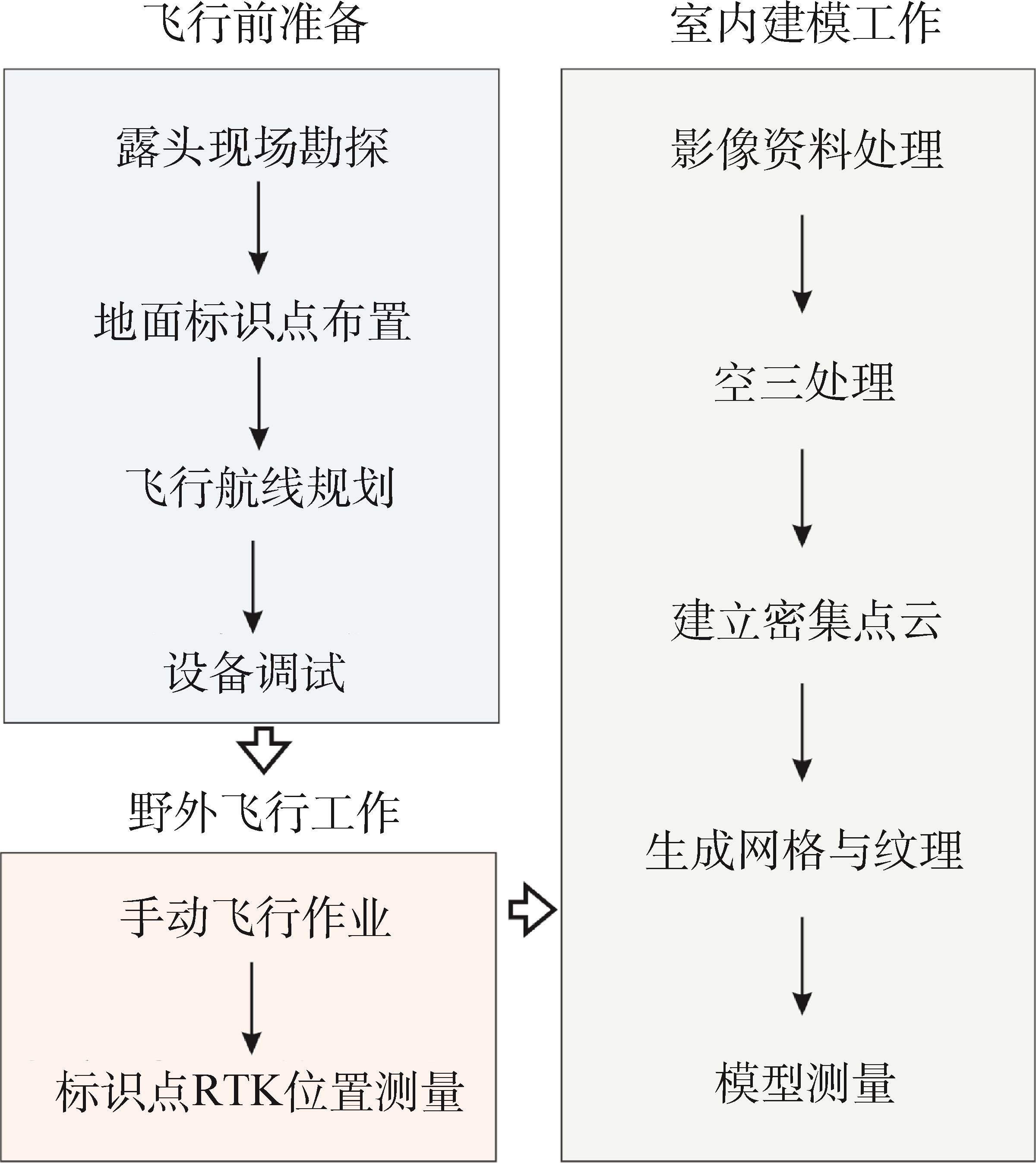
图1 地质露头三维模型构建技术路线图
Fig.1 Technological roadmap of 3D model construction of geological outcrop

图2 无人机倾斜摄影测量技术路线图[37]
Fig.2 Technological roadmap of UAV oblique photogrammetry technology[37]
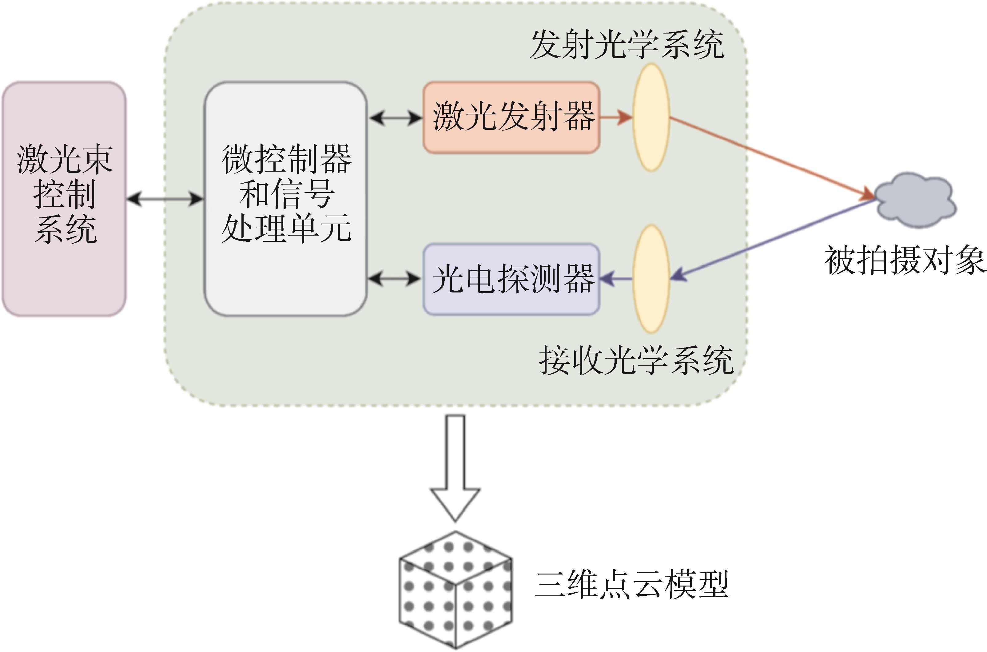
图3 无人机激光雷达技术路线图[43]
Fig.3 Technological roadmap of UAV lidar technology[43]

图4 北京市怀柔区雁栖湖地区遥感影像及地质简图注:遥感影像来自Google Earth,地质简图修编自北京地区1∶50 000岳各庄幅地质图。
Fig.4 Geologic map of Yanqi Lake area, Huairou District, Beijing City

图5 野外工作流程图
Fig.5 Fieldwork workflow diagram

图6 数字三维地质露头模型重建过程图及模型细节图片
Fig.6 Digital 3D geological outcrop model reconstruction process diagram and model detail pictures

图7 地层剖面岩相划分、岩性柱状图及中细碎屑岩显微特征
Fig.7 Lithofacies division of strata section, lithology column diagram, and sampling microscope pictures

图8 三维地质模型中地质现象识别及测量(a)为断层识别;(b)为变形破碎的含火山碎屑粉砂质泥岩;(c)为粉砂岩层透镜体;(d)为方解石脉体填充。
Fig.8 Identification and measurement of geological phenomena within 3D geological models

图9 砾岩砾石粒径测量及统计结果
Fig.9 Measurement and statistical analysis of gravel particle size in conglomerate

图10 三维地质模型精度检验
Fig.10 Assessment of the accuracy of 3D geological models
| ID | 刺点照片数 | 可见照片数 | 重投影误差 RMS/px | 前方交会残差/m | 水平误差/m | 垂直误差/m | 3D误差/m | |
|---|---|---|---|---|---|---|---|---|
| 控制点误差 | Pt1 | 3 | 31 | 0.268 | 0.106 | 0.080 | 0.075 | 0.109 |
| Pt3 | 2 | 20 | 0.103 | 0.088 | 0.127 | 0.007 | 0.127 | |
| Pt4 | 2 | 6 | 0.149 | 0.110 | 0.099 | 0.058 | 0.114 | |
| Pt8 | 2 | 109 | 0.160 | 0.114 | 0.133 | 0.026 | 0.135 | |
| Pt6 | 3 | 54 | 0.396 | 0.081 | 0.143 | 0.019 | 0.145 | |
| Pt5 | 2 | 60 | 0.003 | 0.087 | 0.066 | 0.057 | 0.087 | |
| 检查点误差 | Pt9 | 2 | 32 | 0.07 | 0.051 | 0.139 | 0.033 | 0.143 |
| Pt10 | 3 | 61 | 1.31 | 0.084 | 0.115 | 0.027 | 0.118 |
表1 模型空间坐标精度检查
Table 1 Assessment of coordinate precision in model space
| ID | 刺点照片数 | 可见照片数 | 重投影误差 RMS/px | 前方交会残差/m | 水平误差/m | 垂直误差/m | 3D误差/m | |
|---|---|---|---|---|---|---|---|---|
| 控制点误差 | Pt1 | 3 | 31 | 0.268 | 0.106 | 0.080 | 0.075 | 0.109 |
| Pt3 | 2 | 20 | 0.103 | 0.088 | 0.127 | 0.007 | 0.127 | |
| Pt4 | 2 | 6 | 0.149 | 0.110 | 0.099 | 0.058 | 0.114 | |
| Pt8 | 2 | 109 | 0.160 | 0.114 | 0.133 | 0.026 | 0.135 | |
| Pt6 | 3 | 54 | 0.396 | 0.081 | 0.143 | 0.019 | 0.145 | |
| Pt5 | 2 | 60 | 0.003 | 0.087 | 0.066 | 0.057 | 0.087 | |
| 检查点误差 | Pt9 | 2 | 32 | 0.07 | 0.051 | 0.139 | 0.033 | 0.143 |
| Pt10 | 3 | 61 | 1.31 | 0.084 | 0.115 | 0.027 | 0.118 |
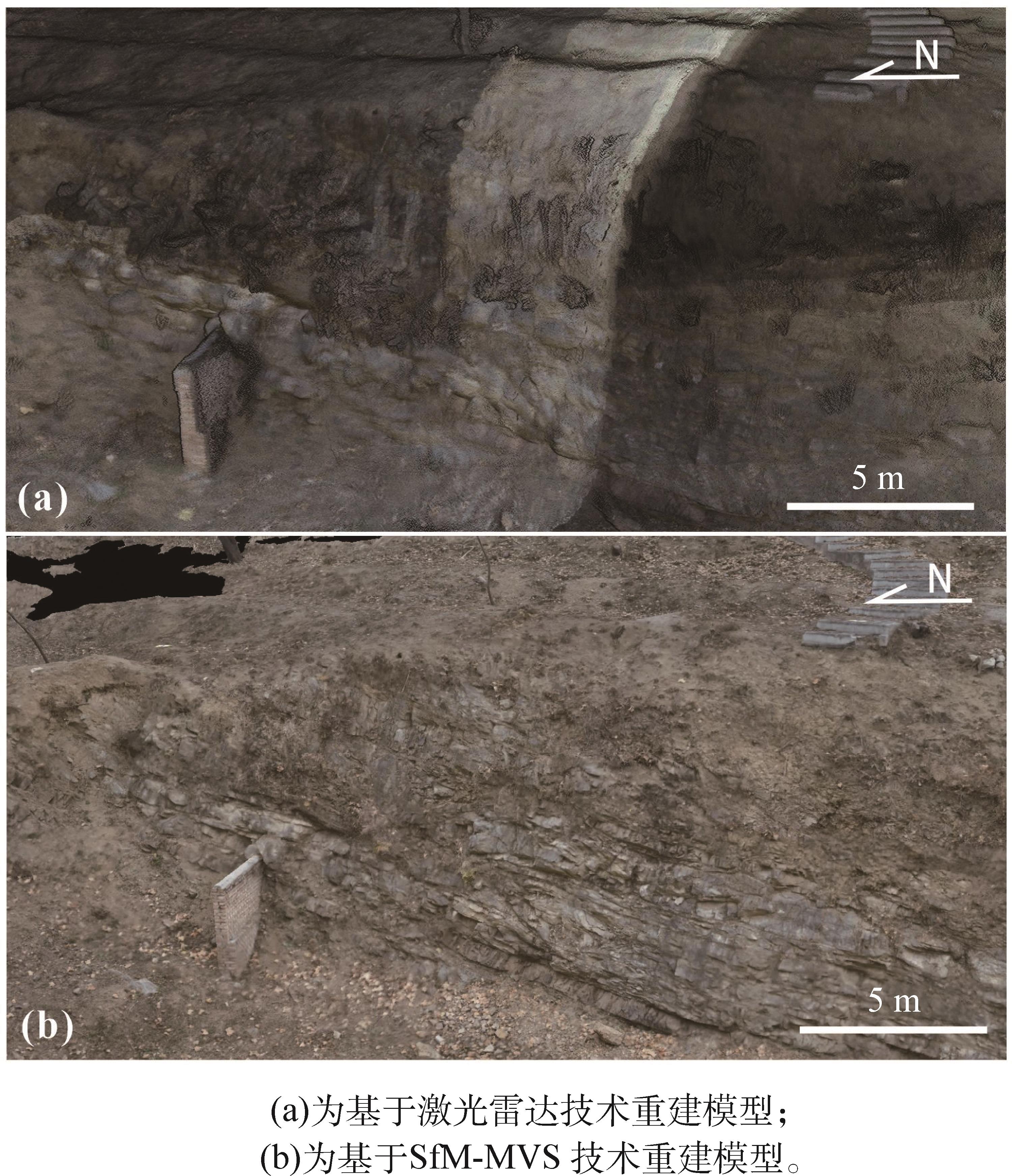
图11 2种模型重建方法对比
Fig.11 Comparative analysis of two model reconstruction methods
| [1] | Usman M, Siddiqui N A, Zhang S Q, et al. 3D geo-cellular static virtual outcrop model and its implications for reservoir petro-physical characteristics and heterogeneities[J]. Petroleum Science, 2021, 18(5): 1357-1369. DOI: 10.1016/j. petsci.2021.09.021 . |
| [2] | Healy D, Rizzo R E, Cornwell D G, et al. FracPaQ: a MATLAB™ toolbox for the quantification of fracture patterns[J]. Journal of Structural Geology, 2017, 95: 1-16. DOI: 10.1016/j.jsg.2016.12.003 . |
| [3] | Thiele S T, Lorenz S, Kirsch M, et al. Multi-scale, multi-sensor data integration for automated 3-D geological mapping[J]. Ore Geology Reviews, 2021, 136: 104252. DOI: 10.1016/j.oregeorev.2021.104252 . |
| [4] | Panara Y, Chandra V, Finkbeiner T, et al. Fracture intensity and associated variability: a new methodology for 3D digital outcrop model analysis of carbonate reservoirs[J]. Marine and Petroleum Geology, 2023, 158: 106532.DOI: 10.1016/j.marpetgeo.2023.106532 . |
| [5] | Pereira J V F, Medeiros W E, Dantas R R S, et al. An integrated 3D digital model of stratigraphy, petrophysics and karstified fracture network for the Cristal Cave, NE-Brazil[J]. Journal of Structural Geology, 2024, 178: 105013. DOI: 10.1016/j.jsg.2023.105013 . |
| [6] | Betlem P, Birchall T, Lord G, et al. High-resolution digital outcrop model of the faults, fractures, and stratigraphy of the Agardhfjellet Formation cap rock shales at Konusdalen West, central Spitsbergen[J]. Earth System Science Data, 2024, 16(2): 985-1006. DOI: 10.5194/essd-16-985-2024 . |
| [7] | Colica E, D’Amico S, Iannucci R, et al. Using unmanned aerial vehicle photogrammetry for digital geological surveys: case study of Selmun promontory, northern of Malta[J]. Environmental Earth Sciences, 2021, 80(17): 551. DOI: 10.1007/s12665-021-09846-6 . |
| [8] | Corradetti A, Tavani S, Parente M, et al. Distribution and arrest of vertical through-going joints in a seismic-scale carbonate platform exposure (Sorrento peninsula, Italy): insights from integrating field survey and digital outcrop model[J]. Journal of Structural Geology, 2018, 108: 121-136. DOI: 10.1016/j.jsg.2017.09.009 . |
| [9] | Martinelli M, Bistacchi A, Mittempergher S, et al. Damage zone characterization combining scan-line and scan-area analysis on a km-scale digital outcrop model: the Qala Fault (Gozo)[J]. Journal of Structural Geology, 2020, 140: 104144. DOI: 10.1016/j.jsg.2020. 104144 . |
| [10] | 乔占峰, 沈安江, 郑剑锋, 等. 基于数字露头模型的碳酸盐岩储集层三维地质建模[J]. 石油勘探与开发, 2015, 42(3): 328-337. DOI: 10.11698/PED.2015.03. 09 . |
| [11] | 程雨柯, 李亚虎, 夏金梧, 等. 无人机技术在超高陡边坡危岩体半自动识别中的应用[J]. 中国地质灾害与防治学报, 2024, 35(1): 143-154. DOI: 10.16031/j.cnki.issn.1003-8035.202310028 . |
| [12] | Menegoni N, Cipriani A, Scarani R, et al. The Cala Viola-Torre del Porticciolo coastal area: a key tectono-stratigraphic site to unravel the polyphase tectonics in NW Sardinia[J]. Italian Journal of Geosciences, 2024, 143(1): 75-104. DOI: 10.3301/IJG. 2024.05 . |
| [13] | Chesley J T, Leier A L, White S, et al. Using unmanned aerial vehicles and structure-from-motion photogrammetry to characterize sedimentary outcrops: an example from the Morrison Formation, Utah, USA[J]. Sedimentary Geology, 2017, 354: 1-8. DOI: 10.1016/j.sedgeo.2017.03.013 . |
| [14] | Tavani S, Corradetti A, Rizzo R E, et al. Best practices towards the digitization of 3D traces from virtual outcrop models[J]. Journal of Structural Geology, 2024, 186: 105222. DOI: 10.1016/j.jsg.2024. 105222 . |
| [15] | Hartwig M E, Santos G G S. Enhanced discontinuity mapping of rock slopes exhibiting distinct structural frameworks using digital photogrammetry and UAV imagery[J]. Environmental Earth Sciences, 2024, 83(22): 624. DOI: 10.1007/s12665-024-11939-x . |
| [16] | Manna L, Perozzo M, Menegoni N, et al. Anatomy of a km-scale fault zone controlling the Oligo-Miocene bending of the Ligurian Alps (NW Italy): integration of field and 3D high-resolution digital outcrop model data[J]. Swiss Journal of Geosciences, 2023, 116(1): 15. DOI: 10.1186/s00015-023-00444-1 . |
| [17] | Triantafyllou A, Watlet A, Le Mouélic S, et al. 3-D digital outcrop model for analysis of brittle deformation and lithological mapping (Lorette cave, Belgium)[J]. Journal of Structural Geology, 2019, 120: 55-66. DOI: 10.1016/j.jsg.2019.01.001 . |
| [18] | Nesbit P R, Durkin P R, Hugenholtz C H, et al. 3-D stratigraphic mapping using a digital outcrop model derived from UAV images and structure-from-motion photogrammetry[J]. Geosphere, 2018, 14(6): 2469-2486. DOI: 10.1130/GES01688.1 . |
| [19] | Conforti M, Mercuri M, Borrelli L. Morphological changes detection of a large earthflow using archived images, LiDAR-derived DTM, and UAV-based remote sensing[J]. Remote Sensing, 2021, 13(1): 120. DOI: 10.3390/rs13010120 . |
| [20] | Menegoni N, Giordan D, Perotti C. Reliability and uncertainties of the analysis of an unstable rock slope performed on RPAS digital outcrop models: the case of the gallivaggio landslide (Western Alps, Italy) [J]. Remote Sensing, 2020, 12(10): 1635. DOI: 10.3390/rs12101635 . |
| [21] | Dąbski M, Zmarz A, Pabjanek P, et al. UAV-based detection and spatial analyses of periglacial landforms on Demay Point (King George Island, South Shetland Islands, Antarctica) [J]. Geomorphology, 2017, 290: 29-38. DOI: 10.1016/j.geomorph.2017.03.033 . |
| [22] | Speed C M, Sylvester Z, Durkin P R, et al. Three-dimensional anatomy of a Cretaceous river avulsion[J]. Geology, 2024, 52(12): 885-890. DOI: 10.1130/G52254.1 |
| [23] | 李亚林, 王成善, 文华国, 等. 数字露头与野外实践教学平台建设趋势与展望[J]. 中国地质教育, 2021, 30(1): 31-35. DOI: 10.3969/j.issn.1006-9372.2021. 01.008 . |
| [24] | 王冉. 基于三维数字露头模型的野外地质教学方法探讨[J]. 中国地质教育, 2019, 28(4): 63-66. DOI: 10.3969/j.issn.1006-9372.2019.04.016 . |
| [25] | 孙信尧, 王平, 张宏, 等. 无人机在沉积学中的应用现状及展望[J]. 地质科技通报, 2023, 42(1): 407-419. DOI: 10.19509/j.cnki.dzkq.2022.0145 . |
| [26] | 陈建华, 钟瀚霆, 侯明才, 等. 数字露头实景三维Web平台研究与云端地质考察应用[J]. 地球学报, 2024, 45(2): 232-242. DOI: 10.3975/cagsb.2023. 112501 . |
| [27] | Nieminski N M, Graham S A. Modeling stratigraphic architecture using small unmanned aerial vehicles and photogrammetry: examples from the Miocene East Coast Basin, New Zealand[J]. Journal of Sedimentary Research, 2017, 87(2): 126-132. DOI: 10.2110/jsr.2017.5 . |
| [28] | Senger K, Betlem P, Birchall T, et al. Digitising Svalbard’s geology: the Festningen digital outcrop model[J]. First Break, 2022, 40(3): 47-55. DOI: 10.3997/1365-2397.fb2022021 . |
| [29] | 刘帅, 陈建华, 王峰, 等. 基于无人机倾斜摄影的数字露头实景三维模型构建[J]. 地质科学, 2022, 57(3): 945-957. DOI: 10.12017/dzkx.2022.054 . |
| [30] | An P J, Fang K, Jiang Q Q, et al. Measurement of rock joint surfaces by using smartphone structure from motion (SfM) photogrammetry[J]. Sensors, 2021, 21(3): 922. DOI: 10.3390/s21030922 . |
| [31] | Bistacchi A, Balsamo F, Storti F, et al. Photogrammetric digital outcrop reconstruction, visualization with textured surfaces, and three-dimensional structural analysis and modeling: innovative methodologies applied to fault-related dolomitization (Vajont Limestone, Southern Alps, Italy) [J]. Geosphere, 2015, 11(6): 2031-2048. DOI: 10.1130 /ges01005.1 . |
| [32] | Saputra A, Rahardianto T, Gomez C. The application of structure from motion (SfM) to identify the geological structure and outcrop studies[C]//AIP Conference Proceedings. Melville:American Institute of Physics, 2017: 030001. DOI: 10.1063/1.4987060 . |
| [33] | Westoby M J, Brasington J, Glasser N F, et al. ‘Structure-from-Motion’ photogrammetry: a low-cost, effective tool for geoscience applications[J]. Geomorphology, 2012, 179: 300-314. DOI: 10.1016/j.geomorph.2012.08.021 . |
| [34] | 魏占玉, Ramon Arrowsmith, 何宏林, 等. 基于SfM方法的高密度点云数据生成及精度分析[J]. 地震地质, 2015, 37(2): 636-648. DOI: 10.3969/j.issn.0253-4967.2015.02.024 . |
| [35] | Wang R, Lin J Y, Li L, et al. A revised orientation-based correction method for SfM-MVS point clouds of outcrops using ground control planes with marks[J]. Journal of Structural Geology, 2021, 143: 104266. DOI: 10.1016/j.jsg.2020.104266 . |
| [36] | 黄五超. 机载激光雷达点云数据分类方法的研究[D]. 西安: 长安大学, 2021. DOI: 10.26976/d. cnki.gchau. 2021.001752 . |
| [37] | Schönberger J L, Frahm J M. Structure-from-motion revisited[C]//2016 IEEE Conference on Computer Vision and Pattern Recognition (CVPR). June 27-30, 2016, Las Vegas, NV, USA. IEEE, 2016: 4104-4113. DOI: 10.1109/CVPR.2016.445 . |
| [38] | Telling J, Lyda A, Hartzell P, et al. Review of Earth science research using terrestrial laser scanning[J]. Earth-Science Reviews, 2017, 169: 35-68. DOI: 10.1016/j.earscirev.2017.04.007 . |
| [39] | Cao T, Xiao A C, Wu L, et al. Automatic fracture detection based on Terrestrial Laser Scanning data: a new method and case study[J]. Computers & Geosciences, 2017, 106: 209-216. DOI: 10.1016/j.cageo.2017.04.003 . |
| [40] | Cawood A J, Bond C E, Howell J A, et al. LiDAR, UAV or compass-clinometer? Accuracy, coverage and the effects on structural models[J]. Journal of Structural Geology, 2017, 98: 67-82. DOI: 10.1016/j.jsg.2017.04.004 . |
| [41] | 张慧, 王娟, 彭涛, 等. 北京云蒙山大水峪韧性剪切带糜棱岩的变形温度[J]. 岩石学报, 2018, 34(6): 1801-1812. DOI: 1000-0569/2018/034(06)-1801-12 . |
| [42] | 赵腾格, 侯泉林, 石梦岩, 等. 北京云蒙山变质核杂岩大水峪韧性剪切带的应变特征及构造意义[J]. 岩石学报, 2021, 37(08): 2483-2501. DOI: 10.18654/1000-0569/2021.08.14 . |
| [43] | Lopac N, Jurdana I, Brnelić A, et al. Application of laser systems for detection and ranging in the modern road transportation and maritime sector[J]. Sensors, 2022, 22(16): 5946. DOI: 10.3390/s22165946 . |
| [44] | 北京市地质矿产局. 中华人民共和国地质矿产部 地质专报: 区域地质 第27号 北京市区域地质志[M]. 北京: 地质出版社, 1991. |
| [45] | 张英芳. 北京西山中侏罗世植物古生态和古地理研究[D]. 北京: 中国地质大学(北京), 2006. |
| [46] | 刘少峰, 林成发, 刘晓波, 等. 冀北张家口地区同构造沉积过程及其与褶皱-逆冲作用耦合[J].中国科学: 地球科学, 2018, 48(6): 705-731. DOI: 10.1360/N072017-00212 . |
| [47] | 张宏仁, 张永康, 蔡向民, 等. 燕山运动的“绪动”: 燕山事件[J]. 地质学报, 2013, 87(12): 1779-1790. DOI: 10.19762/j.cnki.dizhixuebao.2013.12.001 . |
| [48] | Lin C F, Liu S F, Zhuang Q T, et al. Sedimentation of Jurassic fan-delta wedges in the Xiahuayuan basin reflecting thrust-fault movements of the western Yanshan fold-and-thrust belt, China[J]. Sedimentary Geology, 2018, 368: 24-43. DOI: 10.1016/j.sedgeo.2018.03.005 . |
| [49] | 刘仁钊, 马啸. 无人机倾斜摄影测绘技术[M]. 武汉: 武汉大学出版社, 2021. |
| [50] | Menegoni N, Giordan D, Perotti C, et al. Detection and geometric characterization of rock mass discontinuities using a 3D high-resolution digital outcrop model generated from RPAS imagery-Ormea rock slope, Italy[J]. Engineering Geology, 2019, 252: 145-163. DOI: 10.1016/j.enggeo.2019.02.028 . |
| [51] | Perozzo M, Menegoni N, Foletti M, et al. Evaluation of an innovative, open-source and quantitative approach for the kinematic analysis of rock slopes based on UAV based digital outcrop model: a case study from a railway tunnel portal (Finale Ligure, Italy) [J]. Engineering Geology, 2024, 340: 107670. DOI: 10.1016/j.enggeo.2024.107670 . |
| No related articles found! |
| 阅读次数 | ||||||
|
全文 |
|
|||||
|
摘要 |
|
|||||


