Journal of University of Chinese Academy of Sciences ›› 2026, Vol. 43 ›› Issue (4): 507-518.DOI: 10.7523/j.ucas.2024.075
• Environmental Science & Geography • Previous Articles Next Articles
Yating LEI1,2, Zhanfeng SHEN1,2( ), Xinwei YANG1, Bo WANG3, Jinzhou LIU3, Wenqi KOU1,2, Chi ZHANG1,2
Received:2024-05-13
Revised:2024-10-11
Online:2026-07-15
Contact:
Zhanfeng SHEN
CLC Number:
Yating LEI, Zhanfeng SHEN, Xinwei YANG, Bo WANG, Jinzhou LIU, Wenqi KOU, Chi ZHANG. Fire risk assessment method for ancient buildings in the Palace Museum based on spatio-temporal factors[J]. Journal of University of Chinese Academy of Sciences, 2026, 43(4): 507-518.
Add to citation manager EndNote|Ris|BibTeX
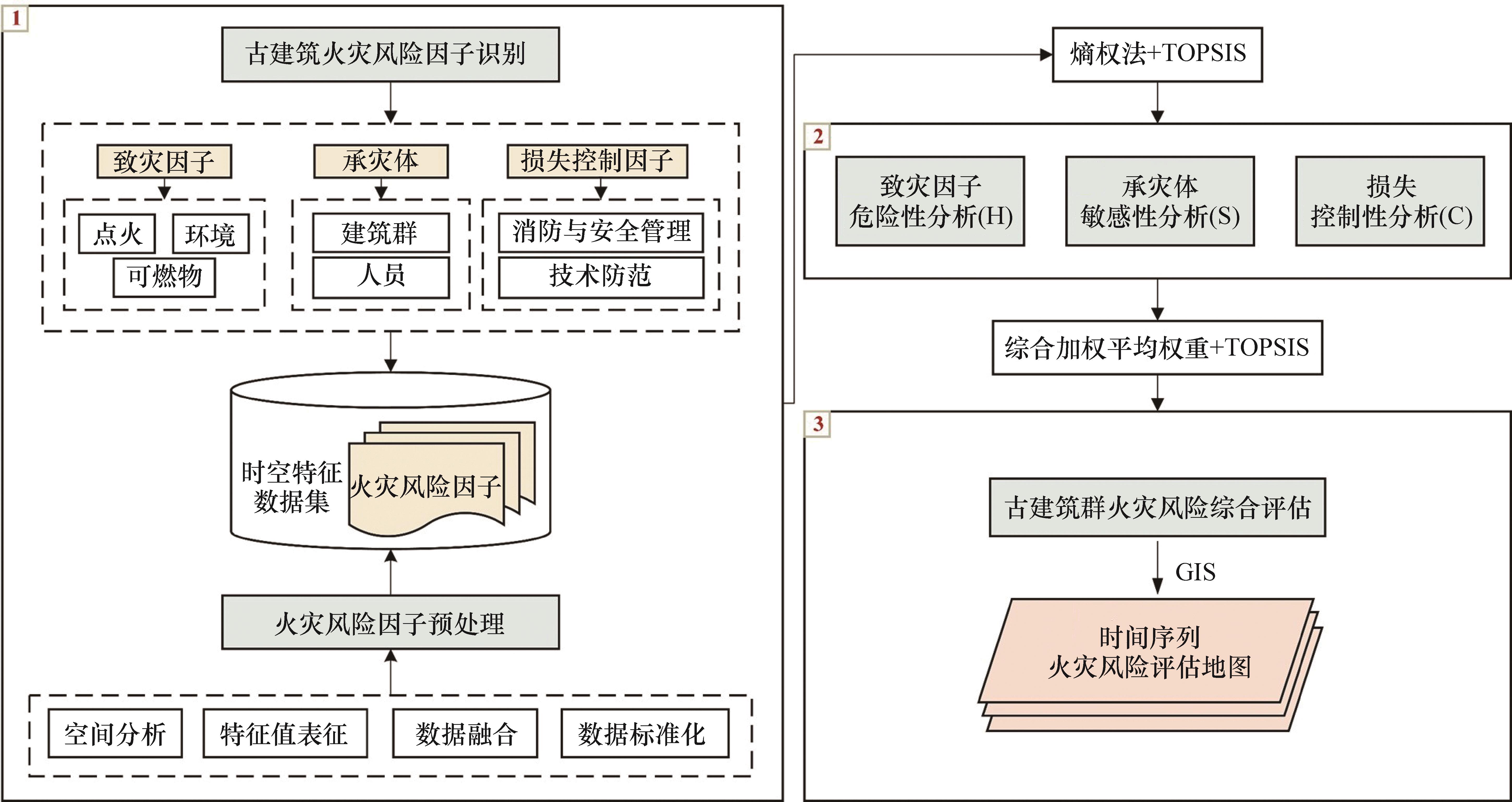
Fig.1 Technical route for fire risk assessment of ancient buildings in the Palace Museum
| 一级指标 | 二级指标 | 三级因子 | 因子描述 | 正负向 | 参考来源 |
|---|---|---|---|---|---|
致灾因子 (H) | 点火 | 用电设施数量 | 单体古建筑内的用电设施数量 | + | [ |
| 燃气使用情况 | 单体古建筑内是否使用燃气 | + | [ | ||
| 可燃物 | 木质结构元素复杂程度 | 单体古建筑木质结构元素的复杂程度 | + | [ | |
| 文物数量 | 单体古建筑内的可移动文物数量 | + | [ | ||
| 植被密度 | 单体古建筑在30 m范围内的植被面积 | + | [ | ||
| 环境 | *最高温度 | 古建筑群所在区域的每月最高温度 | + | [ | |
| *降水量 | 古建筑群所在区域的每月平均降水量 | - | [ | ||
| *相对湿度 | 古建筑群所在区域的每月平均相对湿度 | - | [ | ||
承灾体 (S) | 建筑物 | 建筑物面积 | 单体古建筑的屋顶面积 | + | [ |
| 建筑物功能 | 单体古建筑的功能属性 | + | [ | ||
| 开放程度 | 单体古建筑对游客的开放程度 | + | [ | ||
| 建筑间距 | 单体古建筑间的最邻近距离 | - | [ | ||
| 水系距离 | 单体古建筑的几何中心到水系(路口)的距离 | - | [ | ||
| 道路穿行度 | 单体古建筑在30 m范围内的道路穿行度 | - | [ | ||
| 人员 | *游客数量 | 古建筑群所在区域的每月累计游客数量 | + | [ | |
损失控制 因子(C) | 消防与安全 管理 | 消防管理等级 | 单体古建筑的消防管理等级 | - | [ |
| 安全保护等级 | 单体古建筑的安全保护等级 | - | [ | ||
| 消防站距离 | 单体古建筑的几何中心到消防站的欧氏距离 | + | [ | ||
| 工作人员数量 | 单体古建筑内的工作人员数量 | - | [ | ||
| 技术防范 | 防护圈数量 | 单体古建筑的防护圈数量 | - | [ | |
| 火灾探测系统密度 | 单体古建筑内的火灾探测系统密度 | - | [ | ||
| 火灾报警系统数量 | 单体古建筑在30 m范围内的火灾报警系统数量 | - | [ | ||
| 消防给水系统数量 | 单体古建筑在30 m范围内的消防给水系统数量 | - | [ | ||
| 应急照明及疏散指示系统数量 | 单体古建筑的应急照明及疏散指示系统数量 | - | [ |
Table 1 Description of fire risk factors
| 一级指标 | 二级指标 | 三级因子 | 因子描述 | 正负向 | 参考来源 |
|---|---|---|---|---|---|
致灾因子 (H) | 点火 | 用电设施数量 | 单体古建筑内的用电设施数量 | + | [ |
| 燃气使用情况 | 单体古建筑内是否使用燃气 | + | [ | ||
| 可燃物 | 木质结构元素复杂程度 | 单体古建筑木质结构元素的复杂程度 | + | [ | |
| 文物数量 | 单体古建筑内的可移动文物数量 | + | [ | ||
| 植被密度 | 单体古建筑在30 m范围内的植被面积 | + | [ | ||
| 环境 | *最高温度 | 古建筑群所在区域的每月最高温度 | + | [ | |
| *降水量 | 古建筑群所在区域的每月平均降水量 | - | [ | ||
| *相对湿度 | 古建筑群所在区域的每月平均相对湿度 | - | [ | ||
承灾体 (S) | 建筑物 | 建筑物面积 | 单体古建筑的屋顶面积 | + | [ |
| 建筑物功能 | 单体古建筑的功能属性 | + | [ | ||
| 开放程度 | 单体古建筑对游客的开放程度 | + | [ | ||
| 建筑间距 | 单体古建筑间的最邻近距离 | - | [ | ||
| 水系距离 | 单体古建筑的几何中心到水系(路口)的距离 | - | [ | ||
| 道路穿行度 | 单体古建筑在30 m范围内的道路穿行度 | - | [ | ||
| 人员 | *游客数量 | 古建筑群所在区域的每月累计游客数量 | + | [ | |
损失控制 因子(C) | 消防与安全 管理 | 消防管理等级 | 单体古建筑的消防管理等级 | - | [ |
| 安全保护等级 | 单体古建筑的安全保护等级 | - | [ | ||
| 消防站距离 | 单体古建筑的几何中心到消防站的欧氏距离 | + | [ | ||
| 工作人员数量 | 单体古建筑内的工作人员数量 | - | [ | ||
| 技术防范 | 防护圈数量 | 单体古建筑的防护圈数量 | - | [ | |
| 火灾探测系统密度 | 单体古建筑内的火灾探测系统密度 | - | [ | ||
| 火灾报警系统数量 | 单体古建筑在30 m范围内的火灾报警系统数量 | - | [ | ||
| 消防给水系统数量 | 单体古建筑在30 m范围内的消防给水系统数量 | - | [ | ||
| 应急照明及疏散指示系统数量 | 单体古建筑的应急照明及疏散指示系统数量 | - | [ |
| 数据名称 | 数据来源 | 数据类型 | 分辨率 |
|---|---|---|---|
| 谷歌卫星影像 | 谷歌地球 (http://earth.google.com/) | 栅格 | 0.6 m |
| 气象数据 | 故宫自动气象观测站 | 文本 | — |
| 古建筑信息数据 | 故宫安全技术处 | 文本 | — |
| 设施分布数据 | 故宫安全技术处 | 矢量 | — |
| 消防安全检测数据 | 故宫安全技术处 | 文本 | — |
Table 2 Data sources and types
| 数据名称 | 数据来源 | 数据类型 | 分辨率 |
|---|---|---|---|
| 谷歌卫星影像 | 谷歌地球 (http://earth.google.com/) | 栅格 | 0.6 m |
| 气象数据 | 故宫自动气象观测站 | 文本 | — |
| 古建筑信息数据 | 故宫安全技术处 | 文本 | — |
| 设施分布数据 | 故宫安全技术处 | 矢量 | — |
| 消防安全检测数据 | 故宫安全技术处 | 文本 | — |
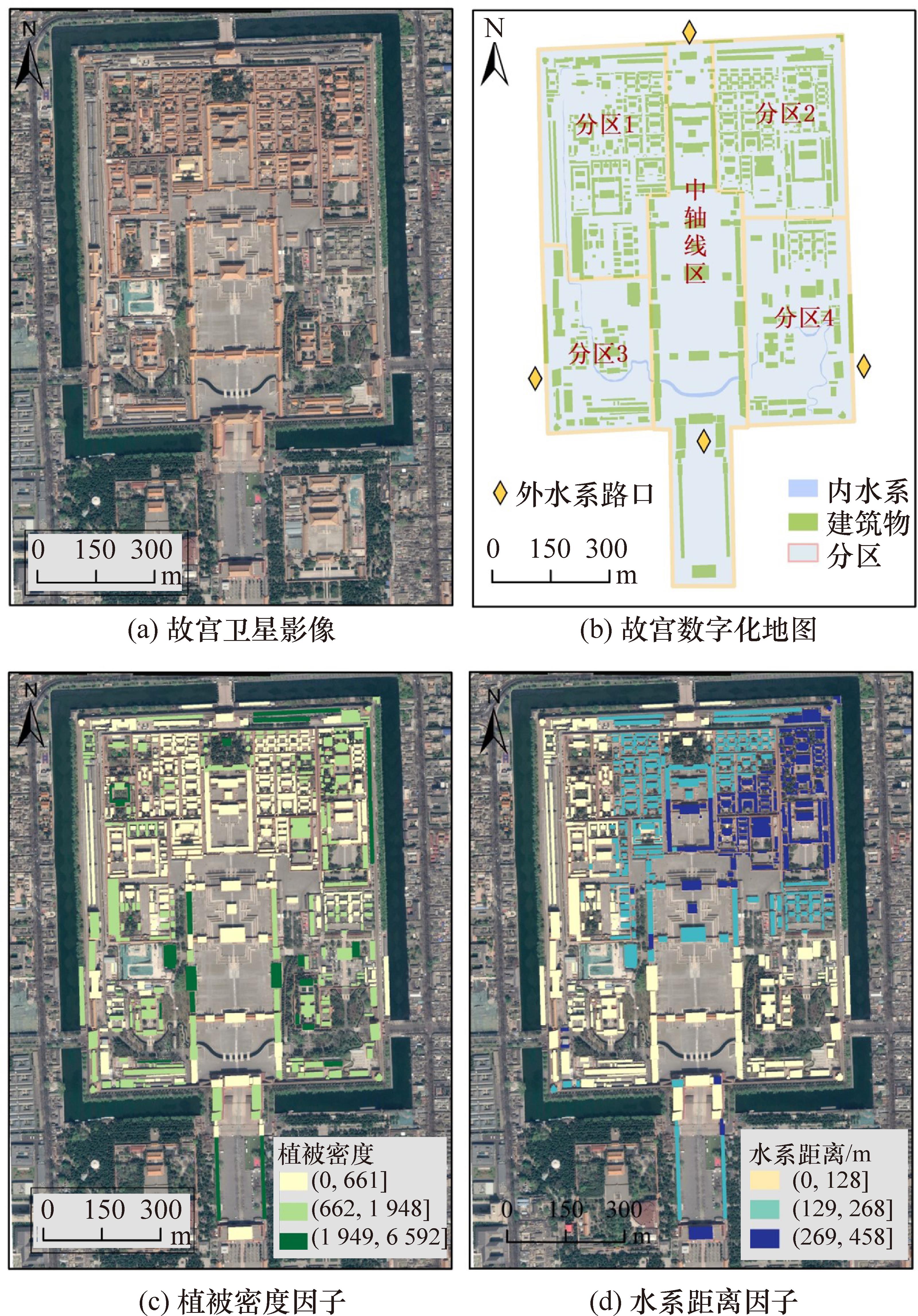
Fig.2 Remote sensing image and part of the processed factor data
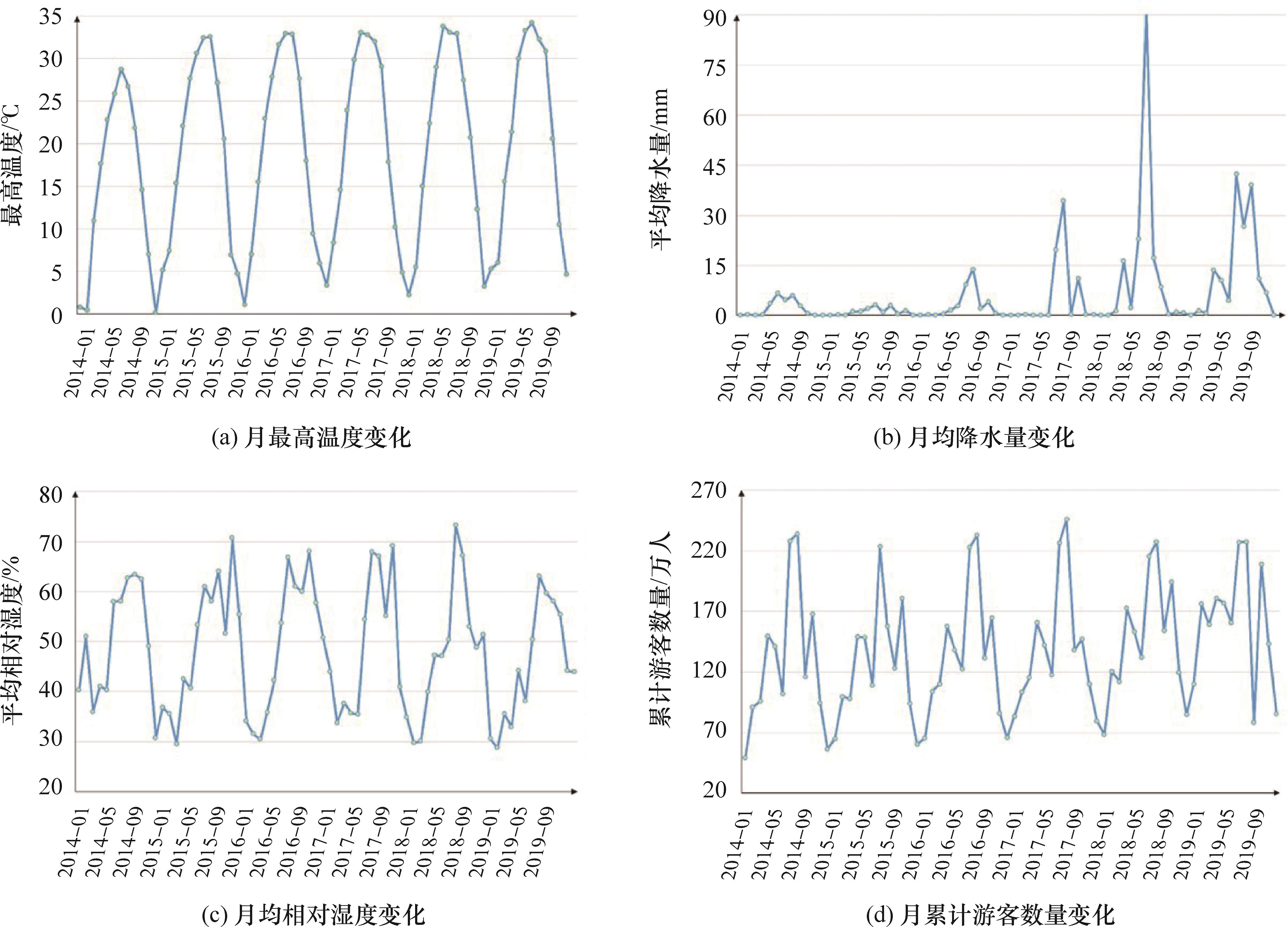
Fig.3 Changes in temporal dynamic factors from 2014 to 2019
| 因子名称 | 因子数据值 | 因子表征值 |
|---|---|---|
| 燃气使用情况 | (否,是) | (0, 1) |
| 文物数量 | (无,少,中,多) | (0, 1, 2, 3) |
| 木质结构元素复杂程度 | (简单,一般,复杂) | (1,2,3) |
| 建筑物功能 | (空置殿,库房,原状陈列殿,办公室,商店,展厅) | (1,3,3,4,4,5) |
| 开放程度 | (否,是) | (0, 1) |
| 消防管理等级 | (低,中,高) | (1,2,3) |
| 安全保护等级 | (低,中,高) | (1,2,3) |
| 工作人员数量 | (无,少,中,多) | (0, 1, 2, 3) |
Table 3 Representation values of category-type factors
| 因子名称 | 因子数据值 | 因子表征值 |
|---|---|---|
| 燃气使用情况 | (否,是) | (0, 1) |
| 文物数量 | (无,少,中,多) | (0, 1, 2, 3) |
| 木质结构元素复杂程度 | (简单,一般,复杂) | (1,2,3) |
| 建筑物功能 | (空置殿,库房,原状陈列殿,办公室,商店,展厅) | (1,3,3,4,4,5) |
| 开放程度 | (否,是) | (0, 1) |
| 消防管理等级 | (低,中,高) | (1,2,3) |
| 安全保护等级 | (低,中,高) | (1,2,3) |
| 工作人员数量 | (无,少,中,多) | (0, 1, 2, 3) |
| 层次 | 因子名称 | 平均分层权重 | 平均综合权重 | 综合权重之和 |
|---|---|---|---|---|
| 危险性H | 燃气使用情况 | 50.12 | 18.13 | 36.20 |
| 木质结构元素复杂程度 | 13.36 | 4.84 | ||
| 用电设施数量 | 12.42 | 4.50 | ||
| 文物数量 | 9.49 | 3.44 | ||
| 植被密度 | 6.18 | 2.24 | ||
| 最高温度 | 3.50 | 1.27 | ||
| 相对湿度 | 3.16 | 1.14 | ||
| 降水量 | 1.77 | 0.64 | ||
| 敏感性S | 游客数量 | 35.35 | 11.77 | 33.30 |
| 开放程度 | 32.59 | 10.85 | ||
| 建筑面积 | 21.52 | 7.17 | ||
| 建筑功能 | 6.43 | 2.14 | ||
| 水系距离 | 2.98 | 0.99 | ||
| 道路穿行度 | 0.84 | 0.28 | ||
| 建筑间距 | 0.29 | 0.10 | ||
| 控制性C | 工作人员数量 | 27.60 | 8.42 | 30.50 |
| 防护圈数量 | 27.17 | 8.29 | ||
| 消防管理等级 | 24.36 | 7.43 | ||
| 安全保护等级 | 11.53 | 3.52 | ||
| 消防站距离 | 5.78 | 1.76 | ||
| 消防给水系统数量 | 2.50 | 0.76 | ||
| 火灾报警系统数量 | 0.47 | 0.14 | ||
| 应急照明和疏散指示系统数量 | 0.40 | 0.12 | ||
| 火灾探测系统密度 | 0.19 | 0.06 |
Table 4 Weights of factors for fire risk assessment of the Palace Museum
| 层次 | 因子名称 | 平均分层权重 | 平均综合权重 | 综合权重之和 |
|---|---|---|---|---|
| 危险性H | 燃气使用情况 | 50.12 | 18.13 | 36.20 |
| 木质结构元素复杂程度 | 13.36 | 4.84 | ||
| 用电设施数量 | 12.42 | 4.50 | ||
| 文物数量 | 9.49 | 3.44 | ||
| 植被密度 | 6.18 | 2.24 | ||
| 最高温度 | 3.50 | 1.27 | ||
| 相对湿度 | 3.16 | 1.14 | ||
| 降水量 | 1.77 | 0.64 | ||
| 敏感性S | 游客数量 | 35.35 | 11.77 | 33.30 |
| 开放程度 | 32.59 | 10.85 | ||
| 建筑面积 | 21.52 | 7.17 | ||
| 建筑功能 | 6.43 | 2.14 | ||
| 水系距离 | 2.98 | 0.99 | ||
| 道路穿行度 | 0.84 | 0.28 | ||
| 建筑间距 | 0.29 | 0.10 | ||
| 控制性C | 工作人员数量 | 27.60 | 8.42 | 30.50 |
| 防护圈数量 | 27.17 | 8.29 | ||
| 消防管理等级 | 24.36 | 7.43 | ||
| 安全保护等级 | 11.53 | 3.52 | ||
| 消防站距离 | 5.78 | 1.76 | ||
| 消防给水系统数量 | 2.50 | 0.76 | ||
| 火灾报警系统数量 | 0.47 | 0.14 | ||
| 应急照明和疏散指示系统数量 | 0.40 | 0.12 | ||
| 火灾探测系统密度 | 0.19 | 0.06 |
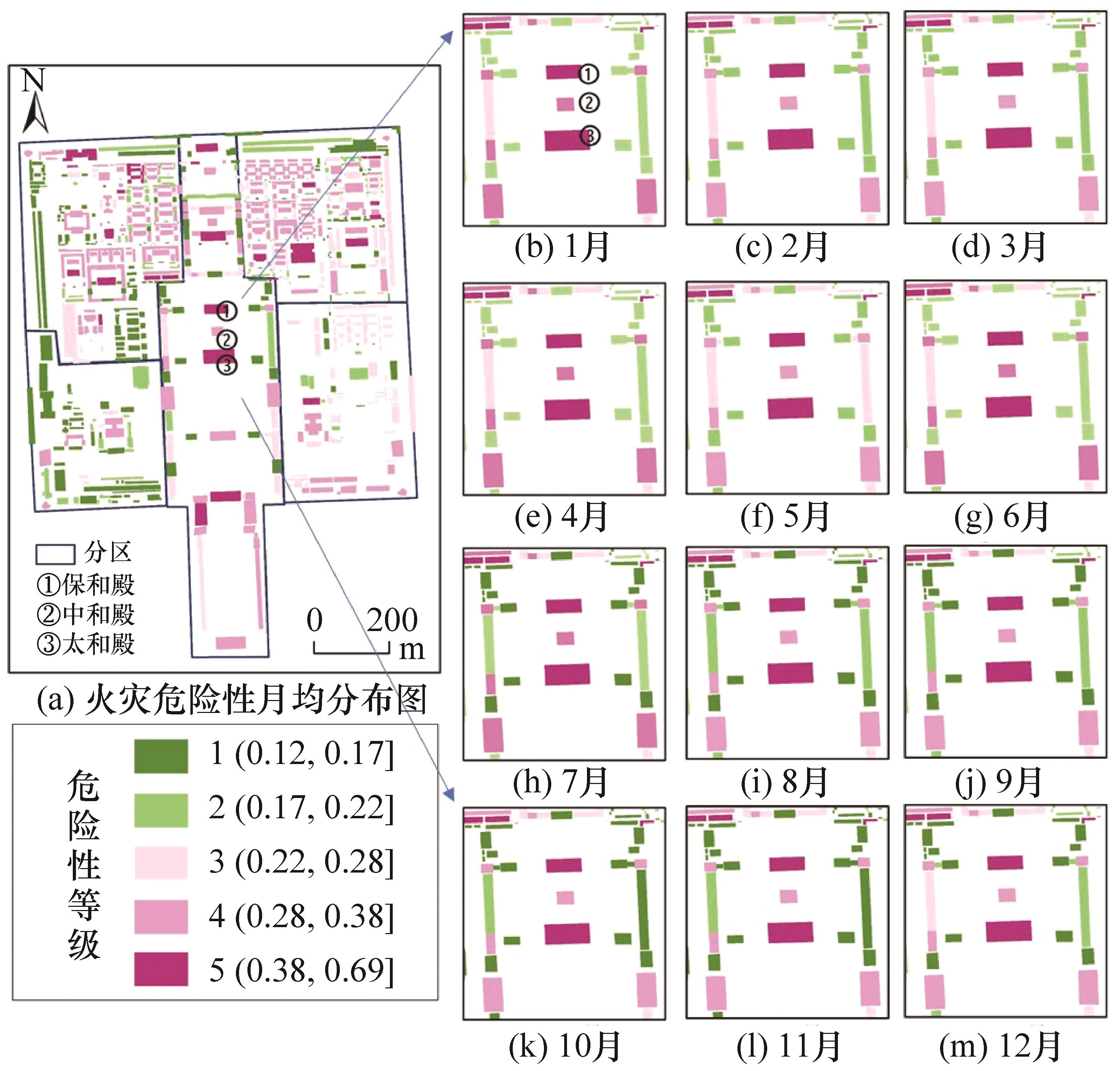
Fig.4 Distribution map of fire hazard grade from 2014 to 2019

Fig.5 Distribution map of fire sensitivity grade from 2014 to 2019
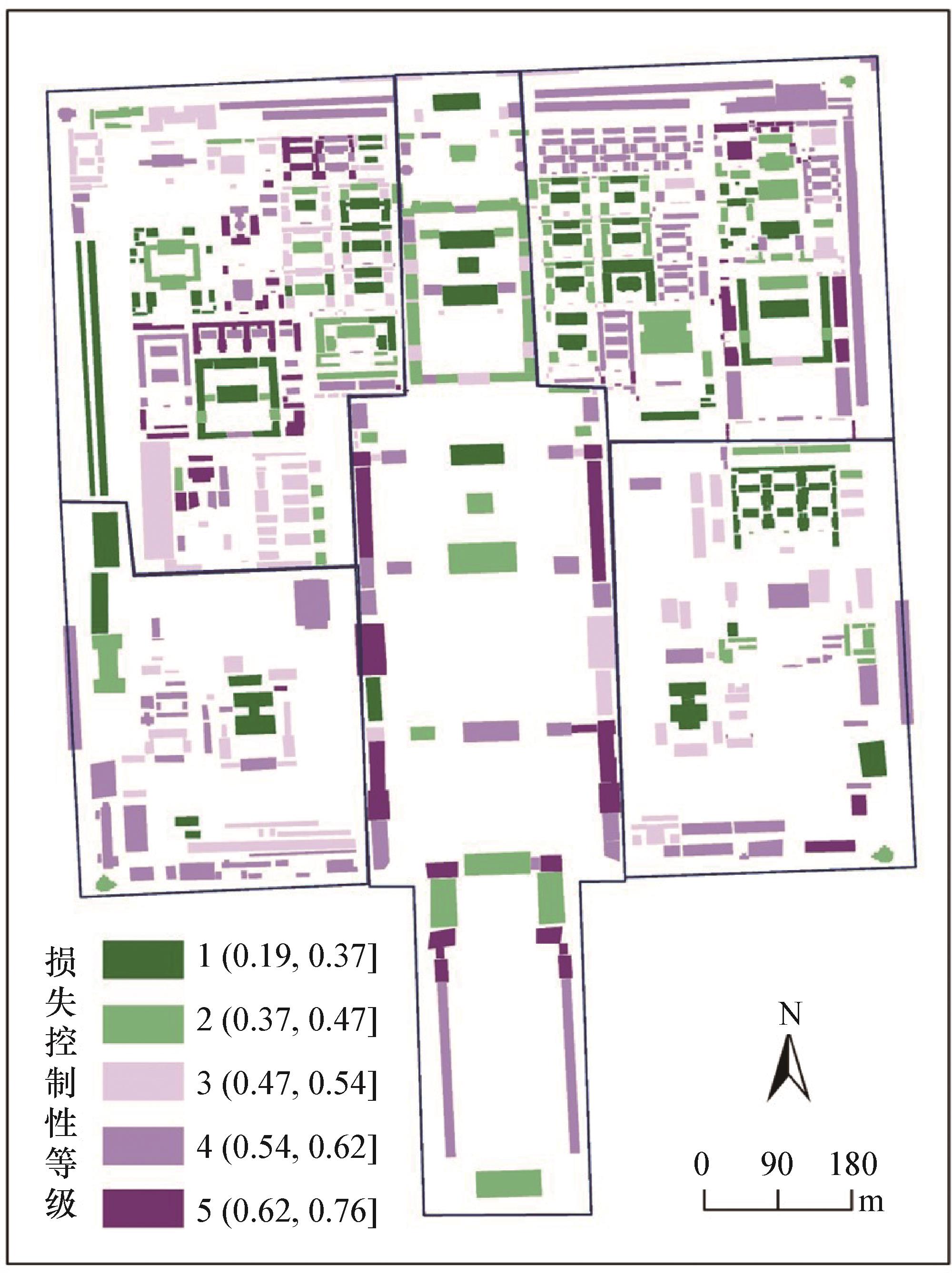
Fig.6 Distribution map of fire control grade from 2014 to 2019
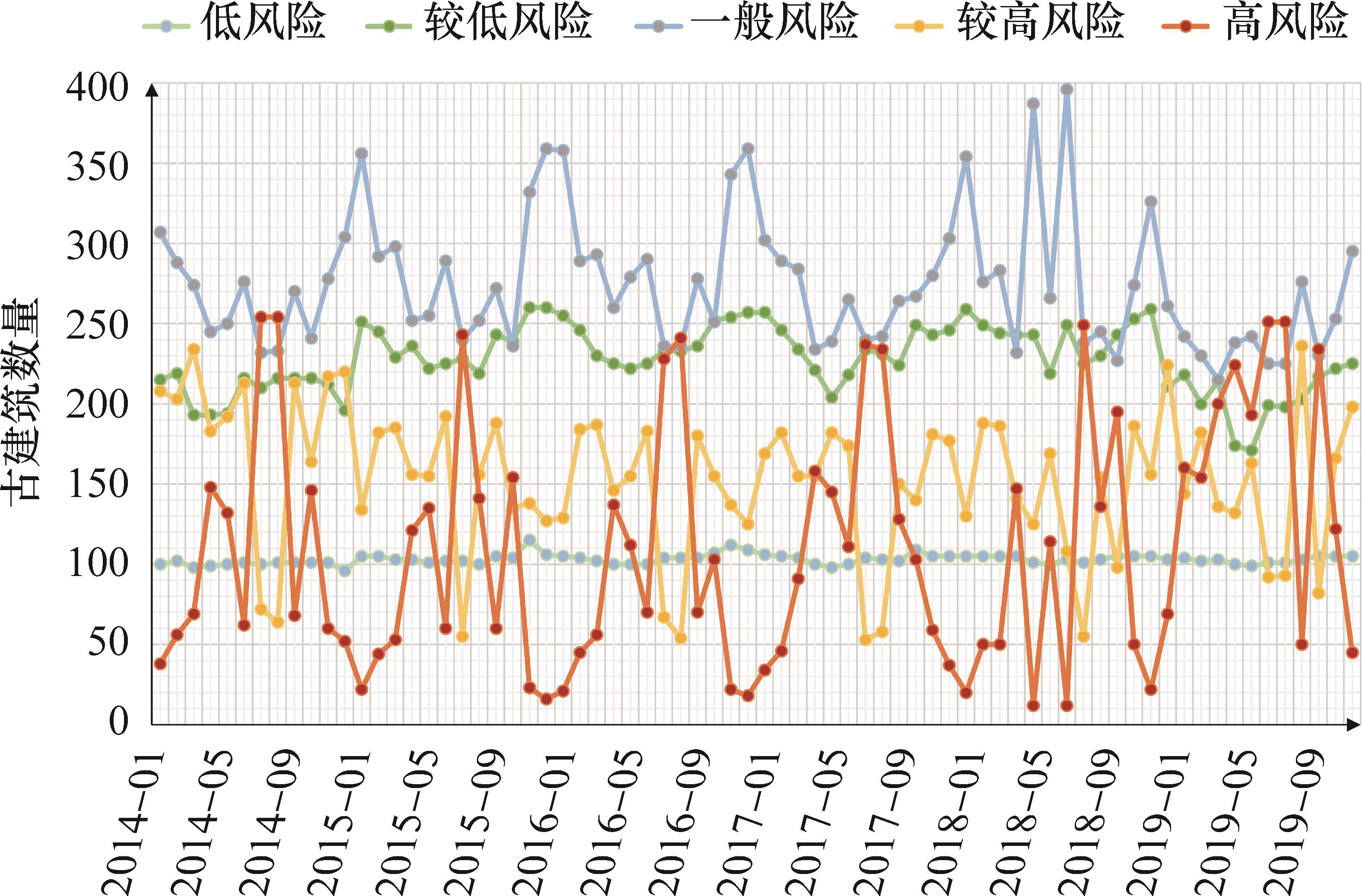
Fig.7 Quantitative change of fire risk comprehensive grade of ancient buildings from 2014 to 2019
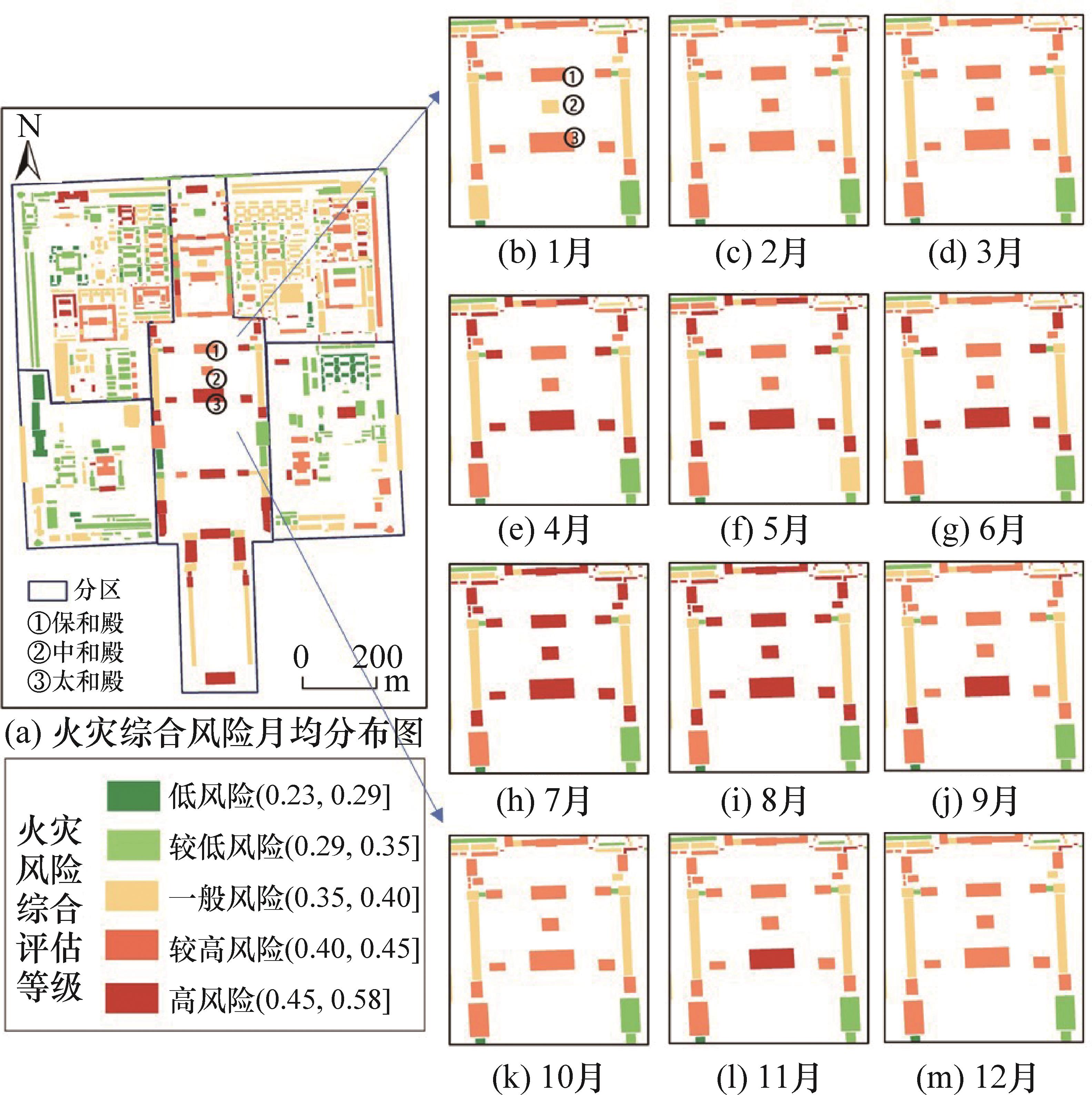
Fig.8 Distribution map of comprehensive fire risk grade from 2014 to 2019
| [1] | 胡安雄, 谢景荣. 文物建筑火灾风险及防控对策研究[J]. 中国文化遗产, 2022, (1): 66-71. DOI: 10.3969/j.issn.1672-7819.2022.01.013 . |
| [2] | Marrion C E. More effectively addressing fire/disaster challenges to protect our cultural heritage[J]. Journal of Cultural Heritage, 2016, 20: 746-749. DOI: 10.1016/j.culher.2016.03.013 . |
| [3] | Watts J M, Kaplan M E. Fire risk index for historic buildings[J]. Fire Technology, 2001, 37(2): 167-180. DOI: 10.1023/A: 1011649802894 . |
| [4] | Kincaid S. The upgrading of fire safety in historic buildings[J]. The Historic Environment: Policy Practice, 2018, 9(1): 3-20. DOI: 10.1080/17567505.2017.1399972 . |
| [5] | Kincaid S. Emergency planning for fire in historic buildings[J]. The Historic Environment: Policy Practice, 2019, 10(1): 19-39. DOI: 10.1080/17567505.2018.1531645 . |
| [6] | Yuan C Y, He Y P, Feng Y B, et al. Fire hazards in heritage villages: a case study on Dangjia Village in China[J]. International Journal of Disaster Risk Reduction, 2018, 28: 748-757. DOI: 10.1016/j.ijdrr.2018.02.002 . |
| [7] | Kincaid S. Fire prevention in historic buildings:approaches for safe practice[J]. The Historic Environment: Policy Practice, 2022, 13(3): 361-380. DOI: 10.1080/17567505.2022.2098633 . |
| [8] | Koutsomarkos V, Rush D, Jomaas G, et al. Tactics, objectives, and choices: building a fire risk index[J]. Fire Safety Journal, 2021, 119: 103241. DOI: 10.1016/j.firesaf.2020.103241 . |
| [9] | Wei Y Y, Zhang J Y, Wang J. Research on building fire risk fast assessment method based on fuzzy comprehensive evaluation and SVM[J]. Procedia Engineering, 2018, 211: 1141-1150. DOI: 10.1016/j.proeng.2017.12.121 . |
| [10] | 李晨. 基于模糊数学的高层建筑消防安全评估方法研究[D]. 武汉: 湖北工业大学, 2016. |
| [11] | Liu F, Zhao S Z, Weng M C, et al. Fire risk assessment for large-scale commercial buildings based on structure entropy weight method[J]. Safety Science, 2017, 94: 26-40. DOI: 10.1016/j.ssci.2016.12.009 . |
| [12] | Mi H F, Liu Y L, Wang W H, et al. An integrated method for fire risk assessment in residential buildings[J]. Mathematical Problems in Engineering, 2020, 2020: 9392467. DOI: 10.1155/2020/9392467 . |
| [13] | Wen Z Z. Based on fuzzy theory analysis method applied to community underground building fire risk assessment[J]. IOP Conference Series: Earth and Environmental Science, 2020, 546(5): 052034. DOI: 10.1088/1755-1315/546/5/052034 . |
| [14] | Kwon H S, Lee J S. A study on the fire fighting general index for fire fighting of crowded wooden building cultural asset[J]. Journal of Architectural History, 2012, 21(2): 37-52. DOI: 10.7738/jah.2012.21.2.037 . |
| [15] | Zhang X, Li X, Mehaffey J, et al. A probability-based Monte Carlo life-risk analysis model for fire emergencies[J]. Fire Safety Journal, 2017, 89: 51-62. DOI: 10.1016/j.firesaf.2017.02.003 . |
| [16] | Li J M, Chen Y Y, Yao X H, et al. Risk management priority assessment of heritage sites in China based on entropy weight and TOPSIS[J]. Journal of Cultural Heritage, 2021, 49: 10-18. DOI: 10.1016/j.culher.2021.04.001 . |
| [17] | Dong X, Lu H, Xia Y P, et al. Decision-making model under risk assessment based on entropy[J]. Entropy, 2016, 18(11): 404. DOI: 10.3390/e18110404 . |
| [18] | Ardianto R, Chhetri P. Modeling spatial-temporal dynamics of urban residential fire risk using a Markov chain technique[J]. International Journal of Disaster Risk Science, 2019, 10(1): 57-73. DOI: 10.1007/s13753-018-0209-2 . |
| [19] | Prieto A J, Verichev K, Carpio M. Heritage, resilience and climate change: a fuzzy logic application in timber-framed masonry buildings in Valparaíso, Chile[J]. Building and Environment, 2020, 174: 106657. DOI: 10.1016/j.buildenv.2020.106657 . |
| [20] | 闫晨, 陈锦涛, 段芮, 等. 韧性城市视角下的历史街区防火韧性评估体系构建[J]. 中国安全生产科学技术, 2020, 16(10): 133-138. DOI: 10.11731/j.issn.1673-193x.2020.10.021 . |
| [21] | Masoumi Z, van L Genderen J, Maleki J. Fire risk assessment in dense urban areas using information fusion techniques[J]. ISPRS International Journal of Geo-Information, 2019, 8(12): 579. DOI: 10.3390/ijgi8120579 . |
| [22] | Brimblecombe P, Hayashi M, Futagami Y. Mapping climate change, natural hazards and Tokyo’s built heritage[J]. Atmosphere, 2020, 11(7): 680. DOI: 10.3390/atmos11070680 . |
| [23] | Arumägi E, Kalamees T. Analysis of energy economic renovation for historic wooden apartment buildings in cold climates[J]. Applied Energy, 2014, 115: 540-548. DOI: 10.1016/j.apenergy.2013.10.041 . |
| [24] | Lee S-Y S. A new fire protection framework that incorporates fire risk indexing for developing and evaluating alternative solutions for Canadian heritage rehabilitation projects [D]. University of Waterloo, 2018. |
| [25] | Parente J, Pereira M G. Structural fire risk: the case of Portugal[J]. Science of the Total Environment, 2016, 573: 883-893. DOI: 10.1016/j.scitotenv.2016.08.164 . |
| [26] | Bernardini G. Fire safety and building heritage: the occupants perspective[M]//SpringerBriefs in Applied Sciences and Technology. Cham: Springer International Publishing, 2017: 7-43. DOI: 10.1007/978-3-319-55744-1_2 . |
| [27] | Granda S, Ferreira T M. Assessing vulnerability and fire risk in old urban areas: application to the historical centre of guimaraes[J]. Fire Technology, 2019, 55(1): 105-127. DOI: 10.1007/s10694-018-0778-z . |
| [28] | Salazar L G F, Romao X, Pauperio E. Review of vulnerability indicators for fire risk assessment in cultural heritage[J]. International Journal of Disaster Risk Reduction, 2021, 60: 102286. DOI: 10.1016/j.ijdrr.2021.102286 . |
| [29] | Naser M Z, Kodur V K R. A probabilistic assessment for classification of bridges against fire hazard[J]. Fire Safety Journal, 2015, 76: 65-73. DOI: 10.1016/j.firesaf.2015.06.001 . |
| [30] | Li J J, Li H W, Zhou B, et al. Investigation and statistical analysis of fire loads of 83 historic buildings in Beijing[J]. International Journal of Architectural Heritage, 2020, 14(3): 471-482. DOI: 10.1080/15583058.2018.1550535 . |
| [31] | Brambilla A, Gasparri E. Mould growth models and risk assessment for emerging timber envelopes in Australia: a comparative study[J]. Buildings, 2021, 11(6): 261. DOI: 10.3390/buildings11060261 . |
| [32] | Ibrahim M N, Abdul-Hamid K, Ibrahim M S, et al. The development of fire risk assessment method for heritage building[J]. Procedia Engineering, 2011, 20: 317-324. DOI: 10.1016/j.proeng.2011.11.172 . |
| [33] | Prieto A J, Vásquez V, Silva A, et al. Protection value and functional service life of heritage timber buildings[J]. Building Research Information, 2019, 47(5): 567-584. DOI: 10.1080/09613218.2017.1404827 |
| [34] | Garcia-Castillo E, Paya-Zaforteza I, Hospitaler A. Analysis of the fire resistance of timber jack arch flooring systems used in historical buildings[J]. Engineering Structures, 2021, 243: 112679. DOI: 10.1016/j.engstruct.2021.112679 . |
| [35] | Dong Q, You F, Hu S Q. Investigation of fire protection status for Nanjing representative historical buildings and future management measures[J]. Procedia Engineering, 2014, 71: 377-384. DOI: 10.1016/j.proeng.2014.04.054 . |
| [36] | Fafet C, Mulolli Zajmi E. Qualitative fire vulnerability assessments for museums and their collections: a case study from Kosovo[J]. Fire, 2021, 4(1): 11. DOI: 10.3390/fire4010011 . |
| [37] | Zhang L, Tian F S, Zheng X, et al. Spatial configuration of fire protection for historical streets in China using space syntax[J]. Journal of Cultural Heritage, 2023, 59: 140-150. DOI: 10.1016/j.culher.2022.11.014 . |
| [38] | 徐欣, 李启路, 唐文娟,等. 历史文化街区改造提升项目火灾风险评估与研究:以重庆市磁器口古镇磁横街片区为例[J]. 消防界(电子版), 2022, 8(7): 27-30. DOI:10.16859/j.cnki.cn12-9204/tu.2022.07.047 . |
| [39] | Fan W C. Fire safety research of historical buildings in China[EB/OL]. (2001)[2024-05-06]. . |
| [40] | He D Y, Xu J Q, Chen X L. Information-theoretic-entropy based weight aggregation method in multiple-attribute group decision-making[J]. Entropy, 2016, 18(6): 171. DOI: 10.3390/e18060171 . |
| [41] | Chen C H. A novel multi-criteria decision-making model for building material supplier selection based on entropy-AHP weighted TOPSIS[J]. Entropy, 2020, 22(2): 259. DOI: 10.3390/e22020259 . |
| [42] | 单霁翔.《故宫保护总体规划》的意义及实施对策[J]. 故宫博物院院刊, 2015(5): 6-16+156. DOI:10.16319/j.cnki.0452-7402.2015.05.001 . |
| [43] | 李月. 吸气式感烟探测报警系统在故宫明清官式高大建筑早期火灾报警的探究[J]. 中国文物科学研究, 2020(2): 26-30. DOI: 10.3969/j.issn.1674-9677.2020.02.005 . |
| [44] | 白成军, 韩旭, 吴葱. 预防性保护思想下建筑遗产变形监测的基本问题探讨[J]. 西安建筑科技大学学报(社会科学版), 2013, 32(2): 54-58. DOI:10.15986/j.1008-7192.2013.02.001 . |
| [45] | 李爱群, 周坤朋, 解琳琳 等. 中国建筑遗产预防性保护再思考[J]. 中国文化遗产, 2021, 101(1): 13-22. DOI: 10.3969/j.issn.1672-7819.2021.01.002 . |
| [1] | Yutao JIANG, Junqi DIAO, Jun XIAO, Ying WANG. Unsupervised 3D registration of articulated shapes by shape and edge regularization [J]. Journal of University of Chinese Academy of Sciences, 2026, 43(5): 657-666. |
| [2] | CHANG Qing, LI Mengke, LU Chenhao, ZHANG Yang. Multimodal medical image registration based on multi-layer feature fusion [J]. Journal of University of Chinese Academy of Sciences, 2025, 42(5): 645-654. |
| [3] | ZHANG Shengrui, SONG Yongyong, ZHANG Tongyan. Spatial distribution characteristics and tourism development potential evaluation of traditional villages in Shandong Province [J]. Journal of University of Chinese Academy of Sciences, 2025, 42(5): 619-631. |
| [4] | WANG Jiaheng, YAN Wei, DUAN Xuejun, DUAN Yanyan, LI Zhuona, ZOU Hui. Basin ecological restoration zoning and land use simulation evaluation based on multivariate coupling model: a case study of Dianchi Lake Basin [J]. Journal of University of Chinese Academy of Sciences, 2025, 42(1): 61-73. |
| [5] | MU Weiyan, JIA Xiaofang, XIONG Shifeng. Interval estimation for the process capability index under the inverse Rayleigh and log-logistic distributions [J]. Journal of University of Chinese Academy of Sciences, 2024, 41(6): 728-735. |
| [6] | GUO Sujie, GUO Chongbin. A pose estimation algorithm for spatial non-cooperative targets based on point cloud registration [J]. Journal of University of Chinese Academy of Sciences, 2024, 41(5): 677-686. |
| [7] | GUO Wenyue, SHI Yusheng. Remote sensing inversion of CO2 emissions from super-large coal-fired power plants in China based on OCO-2/3 satellite [J]. Journal of University of Chinese Academy of Sciences, 2024, 41(4): 490-502. |
| [8] | SHI Zhengyi, LIU Shuo, XIA Hao. A remote sensing image registration method combining feature information clustering and partitioning [J]. Journal of University of Chinese Academy of Sciences, 2024, 41(1): 97-106. |
| [9] | YU Chunyao, FANG Junyong, WANG Xiao, ZHANG Xiaohong, LIU Xue. Band registration method of hyperspectral data based on linear progressive filter imaging [J]. Journal of University of Chinese Academy of Sciences, 2023, 40(3): 406-414. |
| [10] | ZHANG Long, XIAO Jun, CHENG Xiaolong, WANG Ying. 3D point cloud registration via matching multi types of geometric primitives [J]. Journal of University of Chinese Academy of Sciences, 2023, 40(2): 258-267. |
| [11] | ZHUANG Zijun, YUAN Xiaobing, PEI Jun, WANG Guohui, LIU Jianpo. An unsupervised representation learning approach for modelling forest landform characteristics and fire susceptibility assessment [J]. Journal of University of Chinese Academy of Sciences, 2023, 40(2): 227-239. |
| [12] | ZHANG Tao, XIAO Jun, WANG Ying. Point cloud registration method with layer-by-layer filtering of matching points [J]. Journal of University of Chinese Academy of Sciences, 2022, 39(3): 352-359. |
| [13] | ZHENG Jiayi, FANG Junyong, WANG Xiao, ZHANG Xiaohong, LIU Xue. A new band registration method for coated dual-lens multispectral camera [J]. Journal of University of Chinese Academy of Sciences, 2022, 39(3): 377-385. |
| [14] | GUO Meijun, REN Mingyang, LI Shiming, ZHANG Sanguo. Robust ordinal mislabel logistic regression based on γ-divergence [J]. Journal of University of Chinese Academy of Sciences, 2022, 39(3): 289-301. |
| [15] | LIANG Lei, XI Xiaohuan, WANG Cheng, WANG Jinliang, HUANG Youju. A LiDAR data visualized management and analysis system for power line inspection application based on B/S architecture [J]. Journal of University of Chinese Academy of Sciences, 2022, 39(2): 201-207. |
| Viewed | ||||||
|
Full text |
|
|||||
|
Abstract |
|
|||||
Copyright © Journal of University of Chinese Academy of Sciences
Support by Beijing Magtech Co.ltd support@magtech.com.cn

